Color Photograph
Archival Item
2024.7.7
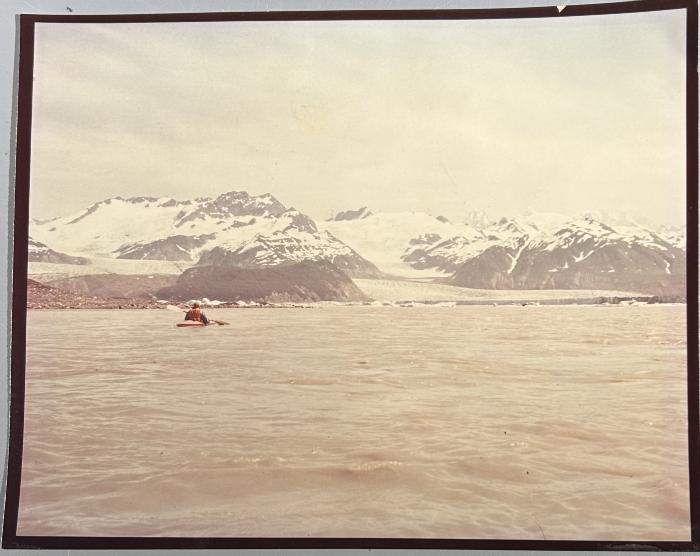
Photograph of 1977 kayak trip on the Tatshenshini and Alsek Rivers [Duplicate]
Colour photograph of kayaker in front of Alsek Glacier.
In the summer of 1977 two Yukon doctors; Larry Otto and Ted Potsepp undertook a kayak trip from Dalton Post to Dry Bay, Alaska on the Tatshenshini and Alsek Rivers. They couldn't obtain local information of the river and did the trip "blind". They bushwhacked in the week before to scout out what they could.
The following is a transcript of the narrative of the trip, written by Larry Otto:
"Account The Tatshenshini (and Alsek) River
The Tatshenshini River is possibly one of the top kayak rivers in the Yukon Territory - in
challenge and most certainly in majestic scenery.
My account of this river may be incorrect with regard to distances, water levels, etc. but they are made to the best of my knowledge.
When I tried to research the Tatshenshini my yield of information was scant. A Mr. Gordon Yardley of Whitehorse travelled this river from Dalton Post some years back with 2 or 3 others in a 4 or 6 man inflatable raft. The most dreaded area of the Tatshenshini - a canyon approx. 4 miles down river from D.P. was then described to me as “fast water with lots of rocks”. The only other information I could gain was from an Alaska ... Magazine (Approx 1975) in an article called Alsek River. It donated about 10 lines to the Tatshenshini, stating it was a beautiful river, about 150 miles and an 8 day trip - good for moderately experienced kayakers. I contacted a Dr. Walt Brachadar of Salmon, Idaho personally and gleaned a bit more information although he couldn’t remember the exact time of the summer (hence the H2O level) that he travelled it.
So the following is my account:
Dr. Ted Potsepp and myself of Whitehorse kayaked from Dalton Post → Dry Bay from July 25th
- August 1st. We were both using Hi P.P. white H20 kayaks as compared to fold boats, hand made wood/canvas boats. From D.P. to Dry Bay we would agree is about 150-200 river miles. It is not an 8 day trip. We spent approx 41/2 hr/day in our kayaks & could’ve easily made the trip in 5-6 days due to the swift current. Exact H20 level drops could perhaps be obtained from H20 Resources although they could be [misleading] as they [vary] at different parts of the river.
We put in at Dalton Post. For the next 3 to 4 miles downstream the H20 is swift but no rapids or dangerous sweepers. At this point the river takes a few sharp turns and fairly quickly you are into a canyon for the next 4 miles. This is the most difficult area on the entire river and I will elaborate on it. One should be clothed in wet suit and helmet as the water is extremely cold and there are many rocks, some below water level, some above. In our case (high water) most were just submerged. I would estimate the water drops 60 to 70 feet per mile over the 4 mile span of canyon. One side of the canyon wall is sheer rock face - the other side you could climb out if you had to. In the event of a dump, you would be very lucky to be able to swim your craft to the canyon’s rather limited shore line, but you could swim out yourself quite alright. Regarding the type of craft, an ordinary canoe would most certainly capsize. If the paddlers were expert, I think they may make it through with a decked canoe with luck, but basically this is a kayaker territory. We consider ourselves medium experienced - certainly not expert, but I would say that a beginner with very limited white H20 experience would likely get into trouble. The grading of the H20 is mainly grade 3 with some areas grade 4, i.e. Grade 3 - waves numerous, high irregular. Rocks, eddies, rapids with passages that are clear though narrow requiring expertise in manoeuvre - experience usually needed. Grade 4 - long rapids, waves powerful, irregular. Dangerous rocks. Boiling eddies. Passages difficult to reconnoiter. Inspection mandatory 1st time. Powerful and precise maneuvering required.
There are 2 spots in the canyon that are grade 4 category - one is approx 1/2 way down - a sharp turn to the right where the boat gets taken up on canyon side wall with a powerful hydraulic below, putting you off balance.
The second spot - more dangerous is about a 4 foot drop of water over some huge rocks visible only from below. It is at the lower part of the canyon where a creek comes in from the left.
After one is out of the canyon the country opens up again and the river is very paddleable (open canoe) for the next 40 miles approx. There is another canyon in this stretch though not dangerous at all.
Then as Detour Creek comes in from the right, from that point on down (70 miles) the river changes into a fast flowing torrent - estimated drop 35 feet per mile. There is numerous rapids, a few dangerous corners, and the river is quite braided with the main channel. The shoreline however is clear. A decked canoe would be quite safe in this stretch though I would think an open canoe would be hazardous as it would take on a considerable amount of water.
The Tatshenshini flows into the Alsek over a huge flat area and where one may think they are going into a big wide river, they are in for a surprise. The Alsek flows as fast, perhaps faster that the Tatshenshini, though with a greater volume and wider river than the Tatshenshini, it makes navigation a lot easier. There are not rapids, but there are several sections with runs of very large standing waves. The Alsek goes in this fashion (approx 40 miles) until it flows into the large bay formed from the spectacular Alsek glacier. There are many massive icebergs in the bay but they provide no hazard to navigation. From the Alsek Glacier to Dry Bay (approx 15 miles) the Alsek is wide, one channel swift but very easier. The area on the map near Dry Bay marked rapids we found were absent at our high water period and we feel they were probably more a landmark for salmon fishing boats travelling upstream to the Alsek Glacier area.
Dry Bay is very flat open country and there is the Dry Bay Fish Company (with radio phone) on the left bank of the river - easily visible as you enter Dry Bay.
Re plane flights out there is an excellent landing strip - suitable even for DC3 at the Fish Company area. Yakatat is about 30 minutes by air. Haines Alaska is approx 2 hours by air (weather conditions permitting)."